
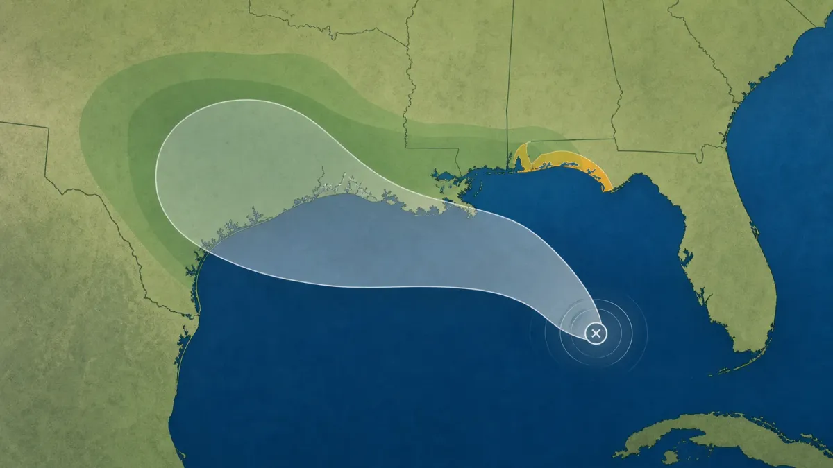
Tropical Depression Two was nearly stationary in the northeastern Gulf of America late Sunday afternoon, July 19, 2026, with a tropical storm watch in effect for part of Florida's Panhandle. The National Hurricane Center said tropical storm conditions are possible there by late Monday.
The system is not a hurricane, but it is already a planning problem for a long stretch of the Gulf Coast. NHC forecasters said the depression is expected to move slowly northwest or north-northwest during the next day or two, then turn west and move near or along the northern Gulf Coast during the next several days.
That slow motion matters because even a modest tropical system can leave repeated bands of rain over the same communities. It also gives households time to do low-regret preparation before a forecast becomes more urgent.
What changed
At 4 p.m. CDT Sunday, the depression's center was near 27.5 degrees north and 85.0 degrees west, about 190 miles south-southeast of Panama City, Florida. Maximum sustained winds were near 30 mph, with gradual strengthening forecast. The NHC expects the depression to become a tropical storm on Monday.
The watch area runs from the Ochlockonee River to the Florida-Alabama border. A tropical storm watch means tropical storm conditions are possible within the watch area, in this case within 36 to 48 hours.
Why the track matters
The main uncertainty is how long the center stays over warm Gulf water and how quickly it bends west. The Houston Chronicle reported that Texas is not under a tropical watch or warning, but the state has entered the forecast picture because the system could turn west later this week.
Rain may become the broader risk even away from the center. The NHC forecast calls for 2 to 4 inches of rain, with isolated totals near 8 inches, from western Florida to the middle Texas coast through Friday. Forecasters said that could cause areas of flash flooding, especially in urban areas.
Storm surge is also a localized concern near the immediate coast. The advisory said normally dry areas could flood from rising water if peak surge lines up with high tide, with 1 to 3 feet possible from Indian Pass to Chassahowitzka, Florida.
What to check now
People in the Florida Panhandle should follow local National Weather Service products for watches, warnings, surge guidance, and evacuation instructions if any are issued. Gulf Coast residents farther west should use the next 24 to 48 hours to confirm they can receive alerts, clear storm drains where safe, review flood-prone routes, and avoid treating the cone as the full impact zone.
Ready.gov's hurricane guidance also recommends keeping emergency supplies, documents, medications, chargers, and a family contact plan where they can be reached quickly if local officials escalate watches or warnings.
For now, the practical takeaway is to monitor official advisories rather than lock onto one forecast line. NHC notes that tropical cyclone effects can extend well outside the track cone, and additional watches or warnings may be needed over the next day or two if the forecast holds.


